Sagamore Bridge, Back Then and Right This Minute
I grew up about 30 miles from the Cape Cod Canal and was always fascinated by what was a great feat of engineering at the time. It allowed coastal shipping to go from New York through the relatively protected waters of Long Island Sound up through Buzzard Bay, then through the Canal and Cape Cod Bay to Boston and points north, shaving a hundred or more miles off the trip, and avoiding going out in the open ocean. It was dug be The Army Corps of Engineers, the sides covered with granite rip-rap to keep the rushing currents from eroding the banks. It was noted for the fishing for striped bass and bluefish, and off the jetties on the north end I caught plenty of pollock and Atlantic mackerel as well.
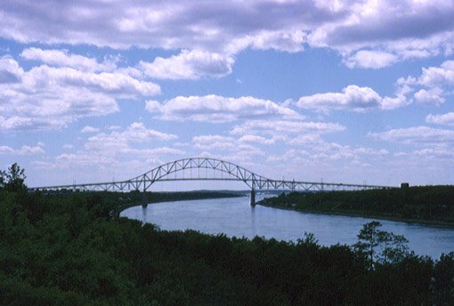
As a kid my dad loved driving to the Cape on a Sunday. He had cousins who lived in Teaticket, a village in the town of Falmouth. He always pointed out the Bourne Bridge on the southern end of the Canal and told me about how when they were pouring the tons of concrete a worker fell in to it. He's still there, with a bronze plaque in his memory affixed to the bridge. The Sagamore Bridge a few miles to the north is essentially the same design, a suspension bridge. I took this photo in the late 1960's.
There was also a third bridge, a railroad bridge, but the section between the two towers was straight across, not arched, and it could be lowered when a train was going to use it or raised way up to allow the ships to pass beneath. Now there are cameras so you can get a live photo of traffic on the bridge and several other nearby places. Check it out! It's a great thing to look at when boredom overcomes you...LOL
http://www.capecodlivecam.com/sagamore.shtml
posted by Al Kaplan at 5:47 PM
![]()
![]()

0 Comments:
Post a Comment
<< Home